၁၉၉၁-၁၉၉၄ ဘူမိေဗဒသူငယ္ခ်င္းမ်ား၏ စတုတၳအႀကိမ္ေျမာက္ အာစရိယပူေဇာ္ပြဲကို ၂၀၁၂ ဇန္န၀ါရီလကုန္တြင္ က်င္းပမည္။ ...........

Monday 19 May 2008

ဘူမိေဗဒေက်ာင္းသားမ်ား သဘာ၀ေဘးအႏၲရယ္ ကူညီမႈအသင္း ဖြဲ႔စည္းျခင္း


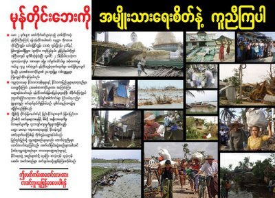
ကၽြန္ေတာ္တို႔ Geology ေနာင္ေတာ္မ်ားမွ NARGIS မုန္တိုင္းဒဏ္မႈမ်ားအတြက္ ကူညီေထာက္ပံေရး အသင္းတစ္ခုဖြဲ႔စည္းခဲ႔တယ္လို႔ ဦးျမတ္ေဇာ္ (၁၉၈၁ geology batch) ထံမွ သိရွိရပါတယ္။
DEAR ALL GEOLOGY FRIENDS
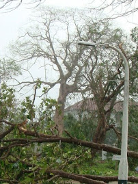
Tonight we all discussed and decided to help devastated people of Myanmar, we formed an Association of Geologists for Natural Disaster Relief. We are just starting action for helping people of Nargis cyclone devastation.
Please pass this message to all and contact our team to contribute. All advices are welcome.
Thank you for all our Myanmar Geologists!!!!!
Association of Geologist for Natural Disaster Relief Team

အသင္းဖြဲ႔စည္းဖြဲ႔စည္းထားမႈမွာ ေအာက္ပါအတိုင္းျဖစ္ပါသည္။

-----------------------------

အကုန္လုံးဖတ္မယ္.....

NARGIS ဒဏ္ခံရေသာ သူငယ္ခ်င္းမ်ား သတင္း


အကုန္လုံးဖတ္မယ္.....

Sunday 11 May 2008

NARGIS ေဘးကူညီေရးအတြက္ လက္ကမ္းစာေစာင္

လက္ကမ္းေၾကာ္ျငာ အဖံုး
-----------------------------
လက္ကမ္းေၾကာ္ျငာ အတြင္း

နီးစပ္ရာသို႔ျဖန္ေ၀ေပးၾကပါ။

အကုန္လုံးဖတ္မယ္.....

ဘိုကေလးၿမိဳ႕ရဲ႕ NARGIS ဒဏ္ရာ


-----------------------------

အကုန္လုံးဖတ္မယ္.....

Wednesday 7 May 2008

NASA Satellite Captures Image of Cyclone Nargis Flooding in Burma


နာဆာ website မွ သတင္းျဖစ္ပါတယ္။ အျခား image မ်ားကို ၾကည့္လိုပါက ဒီမွာ ၾကည့္ရႈႏိုင္ပါတယ္။ The first cyclone of the 2008 season in the northern Indian Ocean was a devastating one for Burma. According to reports from Accuweather.com, Cyclone Nargis made landfall with sustained winds of 130 mph and gusts of 150-160 mph, which is the equivalent of a strong Category 3 or minimal Category 4 hurricane. News reports stated that several thousand people have been killed, and thousands more were missing as of May 5.
-----------------------------
Flood water can be difficult to see in photo-like satellite images, particularly when the water is muddy. This pair of images from the Moderate Resolution Imaging Spectroradiometer (MODIS) on NASA’s Terra satellite use a combination of visible and infrared light to make floodwaters obvious. Water is blue or nearly black, vegetation is bright green, bare ground is tan, and clouds are white or light blue.On April 15, rivers and lakes are sharply defined against a backdrop of vegetation and fallow agricultural land. The Irrawaddy River flows south through the left-hand side of the image, splitting into numerous distributaries known as the Mouths of the Irrawaddy. The wetlands near the shore are a deep blue green. Cyclone Nargis came ashore across the Mouths of the Irrawaddy and followed the coastline northeast.The entire coastal plain is flooded in the May 5 image. The fallow agricultural areas appear to have been especially hard hit. For example, Yangôn (population over 4 million) is almost completely surrounded by floods. Several large cities (population 100,000–500,000) are in the affected area. Muddy runoff colors the Gulf of Martaban turquoise.The high-resolution image provided above is at MODIS’ maximum spatial resolution (level of detail) of 250 meters per pixel. The MODIS Rapid Response Team provides twice-daily images of the region in additional resolutions and formats, including photo-like natural color.

အကုန္လုံးဖတ္မယ္.....